The Maharsha’s Map of Yerushalayim – A Taus Sofer? Berakhot 61b
The Maharsha’s Map of Yerushalayim – A Taus Sofer?
“ברכות סא: “הנפנה ביהודה
רש”י – ירושלים בארץ יהודה היא בצפונה של ארץ יהודה בגבול שבין יהודה לבנימין
By Eli Genauer
תנו רבנן, הנפנה ביהודה לא יפנה מזרח ומערב אלא צפון ודרום, ובגליל לא יפנה אלא מזרח ומערב. ורבי יוסי מתיר, שהיה רבי יוסי אומר לא אסרו אלא ברואה ובמקום שאין שם גדר ובזמן שהשכינה שורה. וחכמים אוסרים
Explanation of Rabbi Steinsaltz per Sefaria, the William Davidson edition of the Talmud
In this context, the Sages taught: One who defecates in Judea should not defecate when facing east and west, for then he is facing Jerusalem; rather he should do so facing north and south. But in the Galilee which is north of Jerusalem, one should only defecate facing east and west. Rabbi Yossi permits doing so, as Rabbi Yossi was wont to say: They only prohibited doing so when one can see the Temple, where there is no fence, and when the Divine Presence is resting there. And the Rabbis prohibit doing so.
רש״י-“הנפנה ביהודה ”
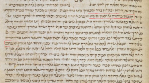
הנפנה ביהודה לא יפנה מזרח ומערב – אחוריו למזרח ופניו למערב ולא אחוריו למערב ופניו למזרח מפני שירושלים בארץ יהודה היא בצפונה של ארץ יהודה בגבול שבין יהודה לבנימין ויש מארץ יהודה הימנה [למזרח] עד סוף ארץ ישראל והימנה למערב עד סוף ארץ ישראל שארץ יהודה על פני כל אורך ארץ ישראל היא מן המזרח למערב כרצועה ארוכה וקצרה ואם יפנה מזרח ומערב יהיה פרועו לצד ירושלים או פרועו שלפניו או פרועו שלאחריו אבל צפון ודרום יפנה ובלבד שלא יפנה כנגד ירושלים ממש בדרומה של ארץ יהודה
Focusing in on the description of where Yerushalayim is located, it says “Because Yerushalayim is in Eretz Yehuda in the north of Eretz Yehuda, on the border between Yehuda and Binyamin, and there is a part of Yehudah which extends to the east until the edge of Eretz Yisroel, and extends westward until the edge of Eretz Yisroel, because Eretz Yehuda extends the entire length of Eretz Yisroel from east to west as a long and short strap.”
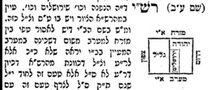
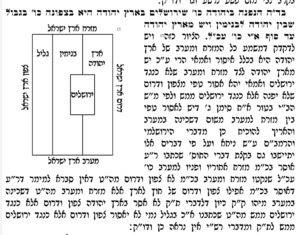
Maharsha – “הציור כזה” – Maharsha draws a map to illustrate the words of Rashi
Vilna Shas – courtesy of hebrewbooks.org

The first thing to consider is does the Maharsha mean that there was a ציור in Rashi?
It does not say “כזה” in Rashi
There was no space left open for a picture in the Bomberg edition of 1520 or the Soncino edition of 1484. This indicates there was no picture on the manuscript that served as the basis for the printed edition. Often חכמת שלמה (Prague 1582) will add a picture or diagram if it was missing from the Bomberg Shas. Here there is no indication of a missing picture in חכמת שלמה.
This manuscript of Rashi on Berachos also does not contain a diagram
The British Library, London, England Or. 5975
Conclusion: Maharsha is drawing a diagram of what he understands Rashi to be saying
We do not have the Ksav Yad of the Maharsha on Berachot so our best knowledge of what he actually drew comes from the Defus Rishon. How was the map represented in that edition?
There were multiple first editions of Chidushei Halachot of Maharsha. The first few Masechtos were printed anonymously. The main one was printed in 1612. Berachos was printed in Lublin in 1621
First edition of Berachos 1621- The picture is the same as the Vilna Shas
courtesy of hebrewbooks.org
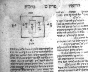
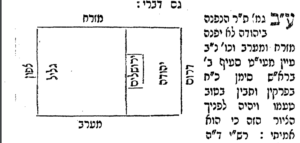
Is the map correct? Does it represent the words of Rashi?
Yerushalayim is represented as being half in Yehuda and half in an area described as Binyamin and Galil. One may argue that the map was not drawn to an exact scale but it seems clear that part of Yerushalayim extends into Binyamin:
The words of Rashi say “Yerushalyim is in Eretz Yehuda in the north of Eretz Yehuda, on the border between Yehuda and Binyamin”. (שירושלים בארץ יהודה היא בצפונה של ארץ יהודה בגבול שבין יהודה לבנימין ) This seems to mean that Yerushalyim is contained within Yehuda and does not extend into Binyamin/Galil.
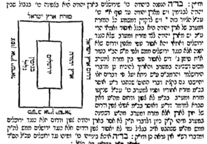
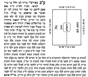
Ginzei Yosef (Bilgoraj 1932 by יוסף אלטר בן מרדכי אפשטיין) calls the map in the Vilna Shas a Taus Sofer and corrects the map to show Yerushalayim completely contained in Yehuda.
courtesy of hebrewbooks.org
There is some space on the east and west sides of Yerushalayim, meaning that Yerushalayim is between the eastern and western borders but does not extend to either border. (see the extra line drawn in on the west side of Yerushalayim). This is in line with the words of Rashi ויש מארץ יהודה הימנה [למזרח] עד סוף ארץ ישראל והימנה למערב עד סוף ארץ ישראל
This is also the opinion of Rav Tziyon Kohen Yehonatan (Djerba 1872-1931) in his Sefer Sha’arei Tziyon ( Dejerba 1932) courtesy of hebrewbooks.org
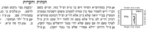
ולענד״ן שטאות סופר נפל בציור וצריך לצייר בענין שתהיה ירושלים כולה נכנסת בגבול של יהודה ולא כמו שכתוב בספרים שהציור הוא שמקצתה בגבול יהודה ומקצתה בגבול של בנימין דאם כן גם מזרח ומערב בארץ בנימין אסור לפנות כשיהיה כנגד ירושלים ודו״ק.
He adds that if Yerushalayim in fact extended any distance into Binyamin, it would require those in Binyamin to also be aware of whether they were facing Yerushalyim or not.
The Sefer D”vash Tamar (Warsaw 1897) by Rabbi Dovid Teitelbaum of Mezeritch draws the map in a similar manner. In this map you can clearly see space between Yerushalayim and the western and eastern borders of Yehuda:
How is the map represented in the newer editions of the Talmud?
Oz Vehadar (Mahaduras Friedman, 2006, Page 42 Maharsha section, Hagahaos V’He’aros) copies the map of Ginzei Yosef but does not have a line on the western side of Yerushalayim. It seems to indicate that Yerushalayim extends to the western border of Yehuda which is incorrect.
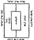
Vilna HaChadash (2006 page 36 in the Maharsha section) redraws the map of the Vilna Shas but still has Yerushalayim extending into Binyamin:
Vagshal (Mahaduras Neherdea, 2008 page 27, Maharsha section) is similar to Vilna HaChadash:
Conclusion: Once something is “uploaded” into the print medium, it has a tendency to remain as it was first printed. In this case, the effects of what many have termed a Taus Sofer have remained for 400 years.